By Alan Brown
Overview
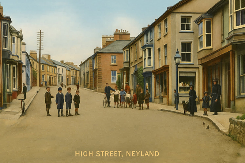
First-time visitors to Neyland today would find a small, quiet town on the north bank of the Milford Haven waterway, with a primary school, a health centre, a few shops, eating-places and churches, and a mixture of unremarkable 19th and 20th century housing. A walk along the Prom would offer them a panoramic view over the water to Pembroke Dock; looking westwards they would see a narrow strip of housing along the waterside, passing the medieval church at Llanstadwell and extending as far as the Ferry House inn at Hazelbeach, while the view to the east would be dominated by the Cleddau Bridge, which has made crossing the Haven a quick and easy undertaking by day or by night, in any kind of weather except the strongest of winds, ever since it opened in 1975. If the visitors carried on their walk along the Prom towards the bridge, they would pass the statue of Isambard Kingdom Brunel and then turn northwards up Westfield Pill, a tidal inlet of the Haven that now provides a scenic home for Neyland Marina with its moorings for more than four hundred yachts and powerboats.
Had these visitors come to gaze across the Haven a hundred and fifty years ago, they would have seen a very different town. Very little physical evidence now remains, but from 1856 to 1963 there was a busy railway terminus where we now have Brunel Quay and the Marina. From here, express trains pulled by steam engines could carry passengers or goods on the Great Western Railway all the way from Neyland to Paddington Station in London without changing. In the second half of the 19th century there was a daily steamship crossing to Waterford in Ireland, while a regular daytime ferry service carried passengers the short distance across the Haven to Pembroke Dock. The ambitions of Brunel, the greatest of the Victorian engineers, transformed the quiet parish of Llanstadwell, and the late 1800s saw the peak of economic activity here. How had all of this come about?
The Earliest People
It is a reasonable assumption that there has been a continuous human presence in south-west Wales since the end of the Ice Age and the retreat of the glaciers. However, these early inhabitants left little physical evidence behind them. A notable exception is the recently-discovered Iron Age chariot that was found buried in a field near the northern boundary of Llanstadwell parish, across the valley from the village of Rosemarket. This is the site of a promontory fort, triangular in shape and protected on two of its sides by steep slopes, and on the third side by earthen embankments that are still clearly visible today.

The Invaders: (1) The Romans
When the Romans conquered Britain in the first century AD, the whole of what is now England and Wales was inhabited by Celtic tribes who spoke languages that were the ancestors of modern-day Welsh; south-west Wales was the home of a tribe called the Demetae, whose name may be the source of ‘Dyfed’.

There is little evidence of the Roman presence further west than Carmarthen, so while the Milford Haven waterway would have made a natural setting-off point for an invasion of Ireland, the land-based Romans seem to have had little enthusiasm for another naval expedition and it appears that Pembrokeshire was largely untouched by them, so the people of Llanstadwell would have carried on living a simple life of farming and fishing, both during and also for hundreds of years after the Roman occupation of Britain.
The Invaders: (2) The Anglo-Saxons and the Vikings
The Roman presence in Britain came to an end early in the fifth century AD, to be succeeded by progressive waves of Angles, Saxons and Jutes who landed and established themselves on the eastern and southern coasts. However, the westward movement of these Germanic people eventually came to a halt at a line running roughly from the River Dee to the River Severn, and this boundary between the native Celts and the newcomers became marked by a long earthen fortification that we now know as Offa's Dyke; the modern-day English-Welsh border still runs very close to this historic line. In its remote location in southwest Wales, Pembrokeshire was untroubled by the drastic social changes that were taking place to the east. However, at the same time, groups of Norsemen were arriving by boat and building settlements at various points along the Milford Haven waterway. They left evidence for this in the form of placenames such as Hakin and Hubberston, while the name of the Milford Haven waterway itself is believed to be derived from the Scandinavian 'fiord', meaning an inlet, rather than 'ford' in the sense of a river crossing. The suffix '-borough' is more commonly found in the areas of northern England that were settled by the Vikings, so it is therefore possible that 'Honeyborough' was also established by Nordic people.
The Invaders: (3) The Normans
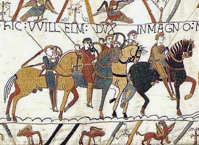
The great change came with William the Conqueror's victory at the Battle of Hastings in 1066, and the subsequent Norman takeover of Anglo-Saxon England. It took another thirty years before the newcomers brought the Celtic people of Dyfed under their control, but the mighty castle at Pembroke became a potent symbol of Norman domination and it gave its name to the whole of the newly-formed county. Within a few years of the construction of this castle the character of the area would be altered forever. King Henry I, who reigned from 1100 to 1135, encouraged a large-scale migration of Flemish settlers into south Pembrokeshire. This would not have been a peaceful process, and the native Celts would have been given a stark choice: either submit to your new masters, leave, or die. The line of castles that runs from Roch to Laugharne formed a border, known as the Landsker, that has endured almost to the present day. To the north of the Landsker lived the native population of Welsh-speaking Celts, while the area to the south became peopled with a mixture of Normans, Anglo-Saxons and Flemings, while any Celts who remained would have had to submit to a life of feudal serfdom. In England, far to the east, the languages of the Normans and the Anglo-Saxons blended over the centuries and eventually became modern English, and this also became the language that was spoken south of the Landsker, so that the southern half of Pembrokeshire came to be regarded as an isolated pocket of Englishness, and therefore acquired the nickname of ‘Little England Beyond Wales’. The parish of Llanstadwell was right in the middle of this.
‘Llanstadwell’ is clearly a name of Celtic origin, combining ‘Llan’, which means church or chapel, with the name of a minor Saint, ‘Tudwal’. This suggests that the church, in one form or another, had existed in its home alongside the Haven since pre-Norman times. However: with this single exception, the present-day names of the villages, farms and settlements in Llanstadwell parish are instead from the era following the Norman invasion, and commonly take the form of the landowner’s name, which was generally Norman, followed by the Anglo-Saxon ‘ton’, which is the root of our modern word ‘town’, but could originally have been applied to small settlements of any kind. Thus, we have Leonardston, Jordanston and Waterston (= Walter’s -ton) and these suggest the names of the local Norman magnates who had received parcels of land in the parish as the reward for their feudal loyalty to the Earl of Pembroke, while he, in turn, had derived his power directly by grant of land from the monarch. Pembroke was one of the so-called 'marcher lordships' which were set up by the Normans to act as a containment and buffer zone against the unruly Welsh. As long as the Earl maintained loyalty to his king, he was granted absolute power over his subjects in his own territory.
From the Middle Ages to the Industrial Revolution
The following three centuries saw occasional attempts by the Celtic Welsh to overthrow their Anglo-Norman masters and to rebuild an independent kingdom of their own, but the failure of Owen Glendower’s rebellion in 1405 marked the beginning of a period of peace and stability in Llanstadwell parish that would see little disruption until the 1850s. By then, the invention of the steam engine in the late 18th century had been powering the Industrial Revolution for more than fifty years, and this had made massive changes to their way of life for many of the people of England, southern Scotland and also the South Welsh coastal towns of Swansea and Cardiff; however, Llanstadwell had been untouched until, in the early 1850s, one man decided that he was going to build a steam-powered ship that was so large that it could cross the Atlantic: this man’s name was Isambard Kingdom Brunel.
The earliest maps of Llanstadwell parish that give us a high level of detail are the first one-inch Ordnance Survey map, dated 1818, and the Tithe Map of c1838. Llanstadwell itself was then just a few houses along the waterside near St Tudwal’s church. Some shipbuilding was carried out on the foreshore here and, in addition, the creation of the Royal Naval Dockyard over the water in Pembroke Dock had given employment opportunities to men who were prepared to make the twice-daily crossings by rowing boat. A mile or so inland from the church were the farming villages of Waterston and Great and Little Honeyborough. On the eastern edge of the parish a minor tidal inlet ran north from the Haven. It had a small settlement on its bank that consisted of little more than a row of cottages and a chapel, and before the coming of the railway its inhabitants would probably have been employed either in farm labouring, fishing, or else in one of the local shipbuilding enterprises that were being carried out on the waterside. This strip of dwellings was the original village of Neyland, and the inlet was at that time marked on maps as Neyland Pill, although it is now normally referred to as Westfield Pill. This undistinguished spot was the location that Brunel chose as a place to build his port, where steamship and steam trains could meet and exchange passengers.
Brunel
Isambard Kingdom Brunel was the visionary Victorian engineer who had built the line that started in London, crossed the River Severn and then ran on through South Wales to Cardiff and Swansea. If his dreams of transatlantic shipping were to become a reality, he needed to create a new port in the west of Wales, and then to extend his railway line westwards to this port so that passengers could transfer directly from train to ship, and vice versa. He chose the calm waters of the Milford Haven estuary as a safe harbour for his massive ocean-going steamship.
Unfortunately for the people who lived in the old village of Neyland, the construction of the railway line required the demolition of their homes so, in order to rehouse them, and also to accommodate the influx of workers who would now be needed to staff the railway, a phase of house building began, and the new town of Neyland started to take the shape that we see today.
By the standards of the 19th century, the new port was a major engineering project. Construction of the railway line required cuttings to be dug into the hillside, while causeways were laid in order to bridge sections where the planned route of the line ran over the water. A massive quay had to be built to allow the visiting ships to dock, with the land flattened behind it to accommodate the railway station. The project was completed in 1856, and in that year both seaborne and railway traffic began to make use of the new facilities. A regular service of small and fast 'packet ships' began to sail between Neyland and Ireland, carrying passengers, mail and assorted merchandise, and on a memorable early occasion a ship named ‘Transit’ arrived at Neyland and took on a cargo of coal and mineral ore that had been brought by rail from Port Talbot and was then to be transported halfway round the world to Australia.
While the Milford Haven waterway was a name that had been familiar since the Middle Ages, and even appears in one of Shakespeare’s plays, nobody in London would have heard the name of Neyland, nor would they have had any idea of where it was located. At that time, the town which we now know as Milford Haven was called simply called Milford (the ‘Haven’ was officially added in 1894) so the managers of the new railway and port took the unfortunate decision to refer to the Neyland terminus as New Milford, and this is the name that appeared on the timetables and on some 19th century maps. When a branch line was later built to the original town of Milford, the railway company tried to change its name to Old Milford but, rather than reducing confusion, this made matters worse. Eventually, New Milford reverted to its original name of Neyland and has kept it ever since.
A Dream Too Far
Brunel had envisaged a great future for his new town of Neyland, and had originally planned it to be the home port for his giant transatlantic steamships: however, the Great Eastern, which had been the largest ship in the world when she was completed, set off instead from Liverpool on her maiden voyage to New York in 1860. On the return journey, however, she did indeed arrive in the waters of Milford Haven and moored at anchor off Hazelbeach. A succession of small boats then conveyed her passengers to the newly-built South Wales Hotel, where they were to stay overnight before walking the short distance to Neyland railway station to start the final leg of their journey. There followed a session of repairs and maintenance on the Great Eastern. This work was carried out on the gridiron, which was a hard surface that had been constructed on the foreshore near to where Neyland Yacht Club stands today.
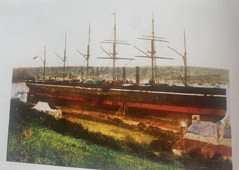
On 1st May 1861 Brunel’s ambition was fulfilled when the Great Eastern set out from Neyland on her second voyage to New York. She made a second visit to Neyland a year later, again for more maintenance work. Brunel, who was arguably the greatest of the 19th century British engineers, had died in 1859, aged just 53, so he never had to face up to the realisation that his wonderful ship was a financial failure that would never fulfil his lofty dreams, and the Great Eastern was scrapped in 1889. Great Eastern Terrace in Neyland was named in the mighty ship’s honour.
A Railway Town
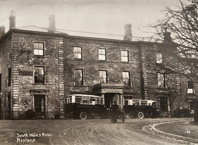
While it would never reach the status that Brunel had hoped for, the new railway terminus at Neyland made the town one of the three centres of 19th century economic growth along the Milford Haven waterway, alongside Pembroke Dock, which had grown up around the Royal Naval Dockyard following its establishment in 1814, and the town of Milford itself, which had come into existence in 1790 as a new town, originally as a whaling port. In addition to the station buildings, accommodation and dining facilities had to be provided for passengers who were spending time here between the two legs of their journeys: the South Wales Hotel, an imposing structure, was built a few yards from the station. The name of the nearby London Coffee House projected a more temperate image that may have been intended to appeal to female passengers. Also, a rapid program of housebuilding accompanied the arrival of the railway, starting at the bottom of the hill and working progressively upwards.
A separate development began on land belonging to a local solicitor, George Parry: this produced the houses on Charles, James and George Streets which were at first collectively known as Parryville, until the upwards spread of new building eventually filled the gap and joined Parryville onto the main body of Neyland. The Royal Naval Dockyard in Pembroke Dock had created a great demand for labour with a corresponding shortage of housing, while at the same time the steam ferry service from Neyland to Hobbs Point provided a safe and reliable commute, and so many of Neyland’s new houses became occupied by families whose menfolk worked over the water. These houses were plain and unpretentious and were built in long, straight terraces; the final one was John Street, which was completed just before 1900, this being the year in which the former village of Neyland became elevated to the status of Urban District. While Neyland had been transformed totally in the second half of the 19th century, the remainder of Llanstadwell parish saw little change.
The 20th Century
The failure to establish itself as the British end of a transatlantic service meant that the less ambitious shipping that was making use of the new port of Neyland consisted of the Irish packets, the Pembroke Dock ferry, trawlers from the fishing trade and a small amount of international cargo traffic. Sadly, a further blow to Brunel’s plans for the town came in 1906, when the Irish packet service transferred instead to the new harbour at Fishguard. This provided a shorter route across the Irish Sea to Waterford or Cork. Local businessmen in Neyland resolved to put the redundant quayside facilities to an alternative use that would create new employment opportunities for the town, and in 1908 a fish market was opened near to the station, while at Barnlake point, on the opposite side of Neyland Pill, an ice factory was built to supply the needs of the fish trade.
Two World Wars
The political developments in the Balkan countries would have seemed very far away to Neylanders in the summer of 1914 but, as with every other community in Britain, they would soon leave a permanent mark. The war that broke out in August of that year was conducted on an unprecedented scale and in a multi-national theatre which eventually gave it the name of ‘The Great War’, although later developments in the 20th century eventually obliged people to refer to it by its subsequent name of ‘The First World War’. It continued for over four years and many of the young men who left to join the Army or Navy would never come home again, while others would return with bodies or minds that were damaged forever by their experiences of fighting for King and Country. The names of thirty-four men from the parish of Llanstadwell are written up on the war memorial.
This war came to an end in November 1918, but although Europe had returned to a temporary state of peace, a further blow came in the following years when it was followed by a world-wide period of economic depression that caused mass unemployment. The communities on the banks of Milford Haven received a crippling shock with the closure of the Royal Naval Dockyard in 1926. This had been south Pembrokeshire’s principal source of employment for more than a hundred years. To some extent it would be true to say that, in economic terms, the area has never really recovered.
The great depression carried on throughout the 1930s. Sadly, it took another war to restore economic activity to Neyland. The Second World War broke out in September 1939, resulting in Pembrokeshire and the Milford Haven waterway once again becoming a hub of military activity. Soldiers, sailors and airmen from many parts of the world were stationed here, bringing an unprecedented cosmopolitan atmosphere to this normally quiet corner of Wales. Inevitably, numerous local men lost their lives in the conflict and, following the end of hostilities in 1945, thirty-five names were added to the ones that were already on Neyland’s war memorial. A stray bomb had caused the deaths of four women in Hazelbeach in 1941, and these names were also included. One further name was added in 1952 as a result of a fatality in the Korean War.
After the War: a Farewell to the Railway and the Ferry
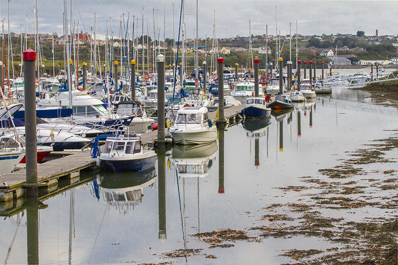
The post-war period brought peace but, as before, it also brought economic depression to the area. Very few people owned their own cars in the 1950s, but the Great Western Railway continued to give Neyland a source of employment and a connection to the rest of the world. Even this would eventually come to an end, however, when the downsizing of the railway system by the 'Beeching cuts' in the 1960s brought the depressing news that Neyland station was to close. A more positive development was the progressive growth of the Milford Haven waterway as a harbour for the oil tankers that were transporting fuel from the Middle East, with several refineries and storage depots being constructed on both banks. The construction and running of these provided jobs for many local workers. At the same time, the resulting increase in traffic created the need for improvements to local roads and in 1975 the Cleddau Bridge was opened; for the first time in history people no longer needed a boat to cross the Milford Haven waterway. Consequently, the ferry service from Neyland to Pembroke Dock became redundant and it ceased operation shortly after the bridge officially opened. Brunel’s great stone quayside at Neyland, which had once been planned as a terminal for passenger ships that would cross the Atlantic, now serves no purpose apart from being an attractive viewpoint; Westfield Pill has become a nature reserve, with the course of the old railway line providing a route for walkers and cyclists. Following the decline of the railway and after twenty years of dereliction, the lower part of the Pill was used for the development of Neyland Marina, which opened in 1985 and provides maintenance facilities and a year-round sheltered mooring for pleasure boats.
Neyland Today
In the present day Neyland has relatively few employment opportunities in its immediate vicinity, while increasing levels of car ownership have largely turned it into a dormitory town, with people generally commuting by car to their place of work. The 2021 census gives the total population as 3,251, with little change over the last twenty years. Nearly one third of these are aged sixty or over: as with the remainder of Pembrokeshire, it has become a popular venue for retirement, with many English people choosing to spend the later part of their life in a part of the world where they had once enjoyed quiet summer holidays. Following on from just over a century of economic activity, over the last fifty years Neyland has gone a long way towards regaining the rural tranquility of pre-industrial times.
Bibliography
Davies, D.N. (1997) The End of the Line – A History of Neyland. Haverfordwest: Pembrokeshire County Council Cultural Services
Ross, D. (2010) Wales – History of a Nation. Glasgow: Waverley Books