By Alan Brown
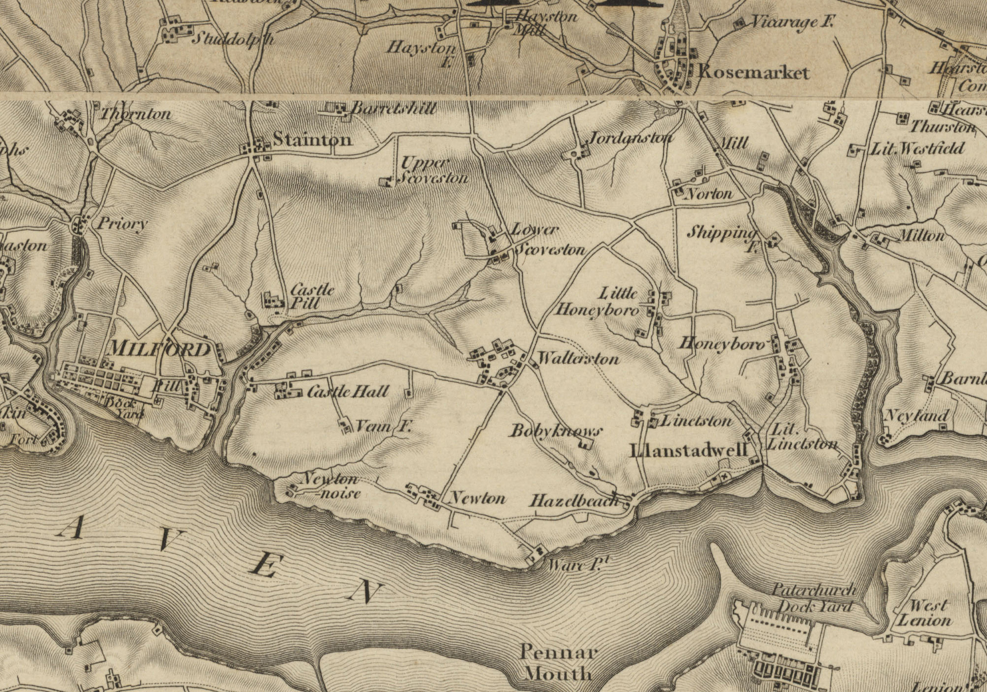
The town of Neyland owes its present-day existence to Brunel’s decision to build a transfer point where Westfield Pill creek meets the Milford Haven waterway, so there would be just a short distance for passengers to walk in either direction between the railway carriages and the packet boats that were crossing the Irish Sea. However, while the steam trains on the Great Western Railway could rapidly carry people and goods overland as far as London, transport by the local roads was a different matter. George Owen’s 1602 map is evidence that, from medieval times, there had been just a single main route connecting Haverfordwest and Pembroke: this is the road that runs through Freystrop, Sardis, Houghton and Burton, bypassing Llanstadwell parish and ending at the point where the Jolly Sailor public house now stands; until the late 19th century this was a turnpike road, which meant that its users had to pay a toll. A small ferry boat, powered by one or two men with oars, would then have covered the short distance to Pembroke Ferry on the south bank of the Haven. At the start of the 19th century the growth of the new town of Milford led to the need to improve the route via Johnston that connected it to the county town; this also became a turnpike. The letters TG on maps of that era indicate the position of the tollgates where the payment for the use of these roads was collected. Llanstadwell parish lies in between these two roads, and its only historic route direct to Haverfordwest was via Rosemarket along a varierty of back lanes and unpaved roadways, so in the year 1800 Llanstadwell was largely self-contained and cut off from the rest of Pembrokeshire.
From the time that the Royal Naval Dockyard opened in 1815, a number of men began to commute daily to work across the water, but the majority of the people of Llanstadwell parish would rarely have needed to travel far from home. Some of the men worked in the shipbuilding yards, while the remainder were mainly farmers or farm labourers. The exception would have been their attendance at Sunday church services, so from the earliest times until the growth of non-conformism in the 17th and 18th centuries, many of the local people would have been making a weekly pilgrimage to the parish church of St Tudwal’s. The better off would have had horses, with or without carts and carriages, while poorer people would have had to walk, with some of their routes eventually becoming the public footpaths that can be seen on present-day maps. Even the wheeled traffic would have been traveling on local roads that were not much better than farm tracks. Long after the introduction of tarmacadam surfaces and powered transport, the roads that served Neyland were still narrow and twisty.
An improvement of the route to the west was needed for the work of building Scoveston Fort, which began in 1861. The materials were conveyed by shipping that docked at Church Lake, with a new roadway then being laid, running north-westward alongside the stream as far as Mastlebridge, and then onward to the construction site. This was referred to as the Military Road, which is the name that it still bears to the present day (see separate article). Shortly before this, in 1858, the ‘Black Bridge’ had been erected across Castle Pill on the eastern side of the expanding town of Milford, so for the first time there was a direct route for wheeled traffic between the two communities.
With the coming of the railway, the new town of Neyland experienced both a rapid growth in population and also a change in traditional employment practices. Men would have been walking from all directions to work at the station, and many of the newcomers would have been heading to services at St Tudwal’s church every Sunday. The direct route along the foreshore as far as Church Lake was stony and difficult at all times and would become completely impassable at high tides, while the stream at Church Lake could only be crossed on foot via a narrow wooden bridge. Horses and wheeled vehicles had to ford the stream directly. The construction of a secure route along the foreshore was not completed until 1910; this linked Neyland up to the Military Road and had required substantial elevation of the roadway to above the level of the highest tides. Initially referred to as the Beach Road, it was eventually renamed The Promenade, and has been generally called ‘The Prom’ ever since. The Military Road was itself improved by resurfacing as a response to the increase in traffic during the first world war. Soon after the construction of The Prom, a road bridge was built across the stream at Church Lake, and this was formally opened at a civic ceremony on 28th June 1911. The overall result was that it then became possible to travel by road from Neyland or Llanstadwell to Milford, without having to negotiate the steep gradient at Hazelbeach.
Apart from the above, there was no significant improvement to the roads in this area until the late 1960s, when the plans were first drawn up to replace the Neyland to Hobbs Point ferry service with a bridge across Milford Haven. The anticipated increase in traffic meant that the overland route south from Haverfordwest would then require major improvement, so the road from Johnston to the northern end of the Cleddau Bridge was widened, straightened and upgraded to ‘A’ road status, and a completely new section laid down, starting at the Honeyborough roundabout and crossing Westfield Pill by means of a smaller secondary bridge that opened to traffic on 1st August 1971.
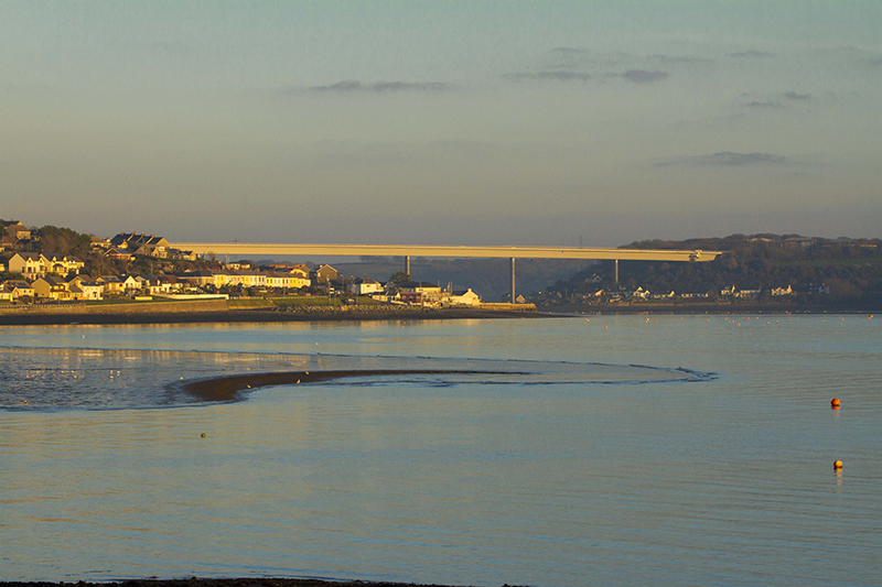
The construction of the Cleddau Bridge itself was delayed by the collapse on 3rd June 1970 of a partially completed section on the Pembroke Ferry side, when four workmen were killed. The bridge was formally opened on 8th March 1975. While this meant that it was now possible for pedestrians and wheeled traffic to cross from Neyland to Pembroke Dock at any time of day, and in any weather apart from strong winds, it also spelt the end for the ferry boats that had been making the crossing since the earliest times. Neyland was now bypassed by this new route, and the Neyland to Hobbs Point ferry ceased operations on the day before the Cleddau Bridge opened.
Ordnance Survey maps are reproduced with the permission of the National Library of Scotland https://maps.nls.uk/