By Carol Elliott
The Story Beneath the Ground
It may come as a surprise to you that the parish of Llanstadwell contains evidence of a settlement dating back some 3,000 years to the Bronze Age. However, beneath the ground at Newton, is evidence of a Bronze Age Roundhouse and the archaeological investigations in 2004 have demonstrated precisely this. The identification of a Bronze Age roundhouse is of particular importance, as well-defined domestic structures of this period are comparatively scarce within Pembrokeshire …. and we have one in Llanstadwell.
But where exactly was Newton?
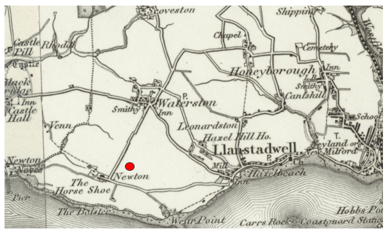
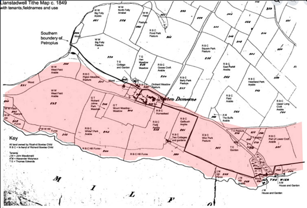
The lands of Newton lay on the northern shore of the Milford Haven waterway, within the parish of Llanstadwell, in the area historically known as Newton Weir and Newton Noyes. We now know that a long lost medieval manor once stood here, described by Richard Fenton as the residence of the “Princely Craddock family”.
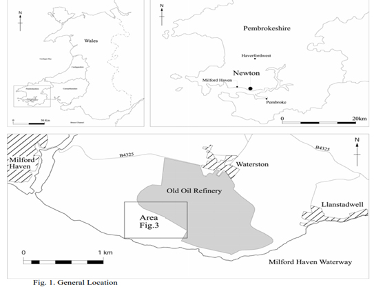
In later years, the site became known as Newton Farm, with a farmhouse, cottages, and agricultural buildings forming a small but active coastal community. Today, however, the lands of Newton lie within the secured industrial boundary of the Dragon LNG facility that was once occupied by Gulf Oil and is no longer accessible to the public.
The physical landscape has largely disappeared, but its history survives through archaeology, documentary records, and local memory. It is therefore important that we continue to explore and reconstruct the history of Newton, uncovering what has been lost and ensuring that its story is preserved for future generations.
Long before the evidence we have of a medieval manor at Newton in Llanstadwell, there is clear archaeological evidence of a much earlier settlement that takes us back some 3,000 years. This is a significant discovery within Pembrokeshire, where evidence for Bronze Age round houses is comparatively scarce and often limited to artefacts rather than structural remains.
Here at Newton in 2004, archaeological investigations were undertaken prior to the development of the Dragon LNG site, and this survey reveals evidence of exceptional chronological depth. Most significant among these discoveries was the identification of a Bronze Age roundhouse, securely dated by radiocarbon analysis to between approximately 1450 BC and 920 BC. This structure provides rare and direct evidence of prehistoric domestic occupation in south Pembrokeshire and establishes Newton as a site of settlement extending back over three millennia.[1]
Long before Newton Medieval Manor, before the farmhouse, and long before the cottages at Newton Weir, this was a place where people lived, worked, and returned to over successive generations that span nearly 500 years.
The Unique Finding of the Bronze Age Roundhouse at Newton
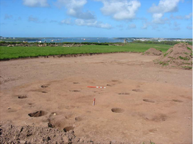
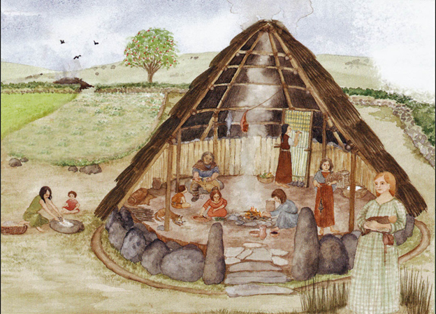
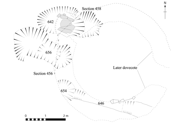
The earliest phase of activity discovered in the 2004 Archaeological Survey at Newton is represented by a prehistoric roundhouse identified through a circular ring of postholes approximately 5.8 metres in diameter, this evidence shows an entrance and possible porch structure.[1] This layout is typical of domestic roundhouses of the later prehistoric period in Britain.
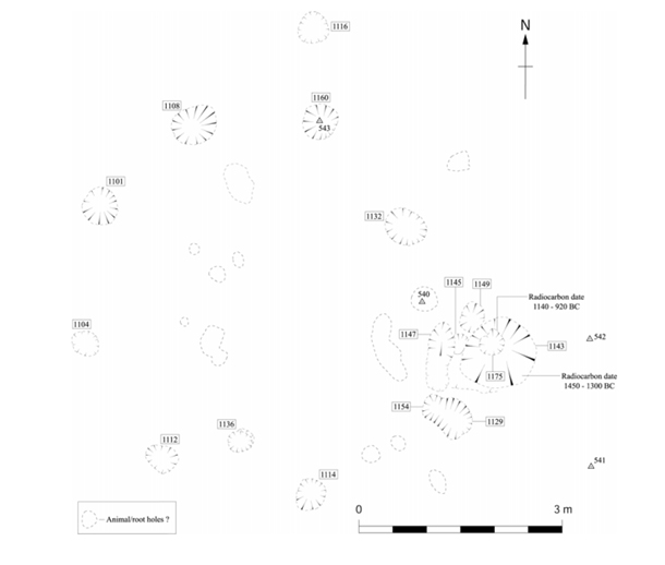
The 2004 Archaeological Survey, by radiocarbon dating from charcoal recovered within the postholes, provides two key results. One sample produced a calibrated date range of 1450 to 1300 BC, while another gave a range of 1140 to 920 BC at 95 percent probability.[1] These dates place the structure firmly within the Middle to Late Bronze Age.
Below is a transcription from the report:
The Bronze Age Roundhouse (Report Transcription)
"The roundhouse was located on the crest of the ridge with extensive views westward down the Haven. It consisted of a circle of postholes approximately 5.8 metres in diameter (contexts 1101, 1104, 1108, 1114, 1112, 1132 and 1160). A double posthole (1129 and 1154) and a deeper posthole (1175) in a post pit (1143) probably formed the entrance, approximately 1.4 metres wide, and a possible porch to the house, along with a shallow gully (1147) and two shallow postholes (1145 and 1149).
One posthole (1136) within the south side of the circle appeared to have been deliberately filled in with a large flat stone. A further posthole (1116), slightly different in form and without packing stones, lay outside the main ring of postholes. There were no obviously artificial features within the post ring. The whole area had, however, been heavily truncated by ploughing, although some post packing remained protruding above the level of the subsoil.
Two fragments of prehistoric pottery (540 and 542), and a flint fragment (541), came from hand cleaning down to the subsoil and did not come from features. Another pottery sherd (543) came from the top fill of a posthole (1160). Two samples of charcoal from the possible entrance post pit (1143) and post pipe (1175) were radiocarbon dated to 1450 to 1300 cal BC (Beta 182945) and 1140 to 920 cal BC (Beta 182944), both at 95 percent probability. [1]"
Bronze Age Pottery (Report Transcription)
"Several sherds of prehistoric pottery were discovered on the highest point of the ridge during a watching brief of topsoil stripping of virtually the whole of The Field and Mount Meadow. The stripping was undertaken to facilitate construction. This area would not form part of the installation itself and therefore soil removal was not complete and no deeper construction is planned.
Limited archaeological excavation seemed to show that the pottery was from a shallow pit, possibly a posthole, the fill of which also contained charcoal specks. It is possible that this pottery is a cinerary urn or a grave good, but given the material from the roundhouse, a domestic context cannot be ruled out.[1]"
These are crucial findings.
It demonstrates that Newton was occupied around three thousand years ago. Yes 3,000 years ago! The presence of two separate date ranges suggests that activity at the site may not have been confined to a single moment in time, but instead reflects reuse or continued occupation across generations within the later Bronze Age.
As said before, the importance of this discovery is heightened by its regional context. Bronze Age settlement evidence of this type is relatively scarce in Pembrokeshire, where surviving material is often limited to isolated artefacts or burial evidence rather than clearly defined domestic structures. The identification of a roundhouse at Newton therefore represents a significant and comparatively rare example of prehistoric domestic occupation within the county. It provides direct structural evidence of how people lived, rather than indirect indications of their presence.
Diet, Farming and Daily Life
The findings of the 2004 excavation provides direct insight into how the inhabitants of Bronze Age Newton lived and sustained themselves 3,000 years ago. Carbonised plant remains recovered from the site show that the occupants cultivated barley, wheat and oats.[1] These cereals formed the basis of the prehistoric diet and indicate a settled agricultural economy rather than temporary occupation.
Woodland Resources and Construction
Charcoal analysis from the excavation provides further detail about the local environment and the materials used by the inhabitants. The identified species include oak, hazel and birch.[1]
These woods reflect both the natural woodland surrounding the site and their practical use. Oak, being strong and durable, was likely used for the main structural posts of the roundhouse. Hazel, which is flexible and easily worked, was well suited to the construction of wattle panels forming the walls. Birch, which burns readily, was probably used as fuel for domestic fires.
This combination of materials allows a clear reconstruction of the roundhouse as a timber-framed structure with wattle and daub walls and a central hearth, built using resources gathered locally from the surrounding landscape.
Fishing and the Coastal Environment
Although no direct evidence of prehistoric fish weirs was identified during the excavation, this coastal position makes it highly likely that marine resources formed part of daily life.
Evidence from Wales demonstrates that tidal fishing and the use of coastal resources have a long history.[5] The later name 'Newton Weir' may preserve this long-standing association between settlement and shoreline exploitation.
Was This an Isolated Round House?
It is important to recognise that only part of the site of Newton was excavated. Wouldn’t it have been wonderful if they could have increased the size of the excavation? Alas!
The identification of a single roundhouse should not be taken to imply that this was an isolated dwelling. At comparable sites across Wales and Britain, such structures typically formed part of small and shifting groups of buildings, and it is entirely possible that further elements of the settlement at Newton have either been lost through later ploughing or remain undetected beyond the excavated area.
At Newton, the radiocarbon evidence, of the Bronze Age findings, span several centuries. This together with comparisons from across the region, suggests that the identified roundhouse formed part of a more extensive settlement, much of which remains unexcavated within the present-day boundary of the Dragon LNG site.
How Many People Lived at Newton?
This roundhouse of approximately 5.8 metres in diameter would typically accommodate a single family group. Based on comparative archaeological evidence, such a structure would likely house between five and eight individuals. If additional structures were present, as is probable, a small settlement of two to four houses could support between fifteen and thirty people at any one time. Newton should therefore be understood as a place of repeated and possibly multi-generational occupation.
Why Newton Was Chosen
The location explains its long-term attraction. The site lies on a ridge overlooking Milford Haven, offering wide views across the waterway and access to coastal resources. It is close to fresh water sources and surrounded by land suitable for cultivation and grazing. The combination of arable land, woodland, and coastal access made Newton a favourable and sustainable place for settlement over long periods of time.
Newton in Its Wider Prehistoric Landscape
Newton does not stand in isolation. It forms part of a wider prehistoric landscape across south Pembrokeshire where other prehistoric sites have been found. On the Castlemartin peninsula, sites such as Castell Mawr and other defended enclosures demonstrate the presence of later prehistoric settlement in the Iron Age. These enclosures typically contained circular timber houses, although these rarely survive as clearly defined excavated structures. Their form indicates small communities occupying enclosed or defensible positions within the landscape.[2]
A similar pattern can be seen at Castell Henllys, where multiple roundhouses were arranged within a defended enclosure. Although this site is later in date than the Bronze Age remains at Newton, it provides an important illustration of how circular houses in west Wales generally formed part of grouped settlements rather than existing as isolated dwellings.[3]
Another nearby comparison is the defended enclosure at Rosemarket, recorded by Cambria Archaeology as an oval rath of Iron Age date, and therefore much later than the Bronze Age roundhouse at Newton. Occupying a naturally protected promontory, it is defined by banks and ditches, particularly strong on its northern approach, showing clear defensive intent but no evidence of internal house structures.[6] This absence is important, suggesting it may have functioned as a stock enclosure or refuge rather than a permanent settlement, in contrast to Newton where the roundhouse provides direct evidence of domestic life.
A more directly comparable Bronze Age site is found at Stackpole Warren, where excavations have revealed a significant assemblage of later prehistoric pottery together with settlement evidence. Radiocarbon dates from associated contexts fall broadly between c.1100 BC and 780 BC, placing the activity firmly within the Late Bronze Age.[7] The pottery forms, including simple flat rims and bucket shaped vessels, closely parallel those pottery forms recovered at Newton, indicating that both sites belonged to the same wider cultural tradition in south Pembrokeshire. Unlike Newton, however, where structural evidence of a roundhouse survives, the importance of Stackpole lies primarily in its ceramic assemblage, which has provided one of the key reference points for identifying and dating Late Bronze Age occupation in the region.
The Corn Dryers and the Quern Stone, post-Bronze Age
Although the Bronze Age roundhouse at Newton provides the earliest clear evidence of settlement, it does not stand in isolation. The archaeological evidence shows that the site was returned to and reused many centuries later after the Bronze Age and long before the emergence of the medieval manor.
Beneath the remains of the later dovecote, the excavations uncovered a series of earlier features, including pits containing large quantities of charred grain. These were identified as the remains of corn driers, used for drying harvested crops.[1]
Scientific dating provides the crucial link in the story. One of these features produced a radiocarbon date of AD 720 to 960, placing it firmly in the early medieval period.[2] This is significant, as it demonstrates that Newton was not simply a prehistoric site later abandoned, but a place that people returned to and worked again over a thousand years after the Bronze Age settlement.
The corn dryers themselves showed clear evidence of use. Their sides had been affected by heat, stones within them had fractured through burning, and their fills contained dense concentrations of carbonised cereals. The grain remains were dominated by oats and barley, with some wheat also present, suggesting mixed farming typical of early medieval Wales.[3]
In a region such as Pembrokeshire, where damp conditions and unreliable harvest weather posed a constant risk, grain could not be safely stored unless it had first been thoroughly dried. Corn dryers provided a controlled means of removing moisture from the crop, preventing spoilage, sprouting, or mould. The condition of the grain at Newton indicates that it had already been processed and was being dried prior to storage when it was accidentally burnt.[4] This provides a rare and direct insight into agricultural practice, showing that crops were not only grown and harvested here, but carefully managed in response to the challenges of the local environment.
Associated with these features was the discovery of part of a rotary quern stone, recovered from the fill of one of the corn dryers.[5] This was the upper stone of a hand mill used for grinding grain into flour. Its presence confirms that the processing of cereals was taking place on site, linking directly with the drying of grain in the nearby pits.
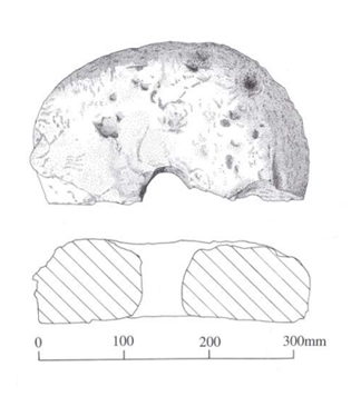
Grinding grain was not a quick task. Experimental and ethnographic evidence suggests that grinding sufficient flour to produce a single loaf of bread could take one to two hours of steady work, depending on the fineness required and the condition of the grain.[9] The process was physically demanding, repetitive, and essential to daily life. Flour was not produced in bulk and stored for long periods but typically ground as needed.
In early medieval households, this work most likely formed part of the routine domestic labour carried out within the family. While direct evidence is limited, both archaeological interpretation and historical analogy indicate that women were primarily responsible for grain processing and food preparation, often assisted by older children.[10] The presence of the quern at Newton therefore points not only to agricultural activity, but to the day-to-day life within the household, where harvested grain was dried, ground, and prepared for consumption.
Its discovery within the fill of the corn dryer suggests that it had been discarded after use, perhaps when the feature fell out of use or the working area was reorganised. Even so, it provides a direct and tangible link between the cultivation of crops and their transformation into food, completing the chain of agricultural activity taking place at Newton during the early medieval period.
In this way, we can see the site at Newton begins to bridge the long chronological gap between the Bronze Age roundhouse and the later medieval occupation. The evidence suggests not continuous settlement, but a pattern of return, a landscape repeatedly chosen for habitation and farming over many centuries, leading ultimately to the development of the medieval manor at Newton.
A Landscape of Long-Term Use
This strong archaeological evidence at Newton reveals a pattern of repeated occupation across a very long period, three thousand years. The Bronze Age roundhouse demonstrates settlement between approximately 1450 BC and 920 BC. The early medieval corn drying kiln shows renewed activity between AD 720 and 960. These phases demonstrate that Newton was a place that people returned to across very different periods of history.
What This Means for Newton
The discoveries at Newton fundamentally change how we should understand the site.
It was not simply a later settlement or even just a medieval manor. It was a long-lived landscape, occupied and reused over more than three thousand years.
So for us who remember: Newton …… was not an isolated farm. It was a place of continuity, settlement, and human activity stretching back three thousand years.
Map is reproduced with the permission of the National Library of Scotland https://maps.nls.uk/
Footnotes
[1] Pete Crane, Excavations at Newton, Llanstadwell, Pembrokeshire (Cambria Archaeology Report 2004/73), including radiocarbon dating, archaeobotanical evidence, charcoal analysis, pottery report by Ann Woodward, and finds analysis.
[2] Archaeological evidence from Stackpole Warren and prehistoric enclosure sites in south Pembrokeshire.
[3] Pembrokeshire Coast National Park Authority, Castell Henllys Iron Age Village; Cadw records.
[4] Archaeological and historical record for Rosemarket, including enclosure and later manorial features.
[5] Gwynedd Archaeological Trust, Coastal Fish Weirs and Traps in Wales.
[6] K. Murphy et al., A Survey of Defended Enclosures in Pembrokeshire, 2006–07 (Cambria Archaeology Report No. 2007/01, 2007), Rosemarket Rath entry.
[7] T. Darvill, “Later Prehistoric Settlement at Stackpole Warren,” in Prehistoric Pembrokeshire (1990); see also A. Woodward, pottery comparison in Pete Crane, Excavations at Newton, Llanstadwell, Pembrokeshire (Dyfed Archaeological Trust, 2004).
[8] Redknap, M., Vikings in Wales: An Archaeological Quest (Cardiff, 2000).
[9]Peacock, D.P.S., The Roman Millstone Trade (Oxford, 1980); Reynolds, P.J., experimental work at Butser Ancient Farm on hand quern grinding rates.
[10] Hamerow, H., Early Medieval Settlements: The Archaeology of Rural Communities in North-West Europe 400–900 (Oxford, 2002); also supported by ethnographic parallels in traditional agrarian societies.