By Carol Elliott
Did you know that long before Neyland existed as a town, the main ferry crossing of the Cleddau, from this side of the water, lay between Burton and Pembroke Ferry, and that in medieval records it was known as the Passagium?
This was not just a local ferry. It was the main transport route between Pembroke and Haverfordwest, carrying people, animals, and goods across the Cleddau. The crossing was regulated, leased, and recorded, appearing in fifteenth-century accounts as the ‘Passage at Burton’, confirming its place within the administration of the lordship of Pembroke. The story of crossing the Cleddau begins here, where the road once met the water, and where for centuries the Haven was crossed by a working medieval ferry.
Long before the Neyland to Hobbs Point ferry became part of railway and dockyard life, the chief crossing on this side of the Haven was the old passage from Burton to Pembroke Ferry. In medieval and later records this crossing was known as the Passagium, and it was not a casual local boat service but a recognised route of legal, economic, and strategic importance. It formed the main passage joining the road from Pembroke to Haverfordwest. That is the key to its significance. Before modern bridges and before the rise of Neyland as a transport hub, this was the quickest and most practical way of carrying people, animals, goods, and wheeled traffic across the upper Haven.[1][2]
History recorded by the Neyland Women’s Institute, in their scrapbook circa 1950, is extremely valuable because it preserves a local historical tradition that is firmly rooted in documentary evidence. The typed notes state that the river “was crossed in the early days at the ‘Passage’, referred to frequently in very early records, by the Latin title of Passagium”, and place it “roughly where a crossing from Trinity Wharf, Burton would be made to Pembroke Ferry.”
The same notes add that the rights of ferrying passengers and animals at this site were “farmed out” annually, which is exactly the language of a regulated manorial or borough income rather than an informal boat hire. They also record a reference in the Slebech Papers to an account of Henry Wogan, dated 1 July in the first regnal year of Henry V, (1413) for amounts owing from the Passage at Burton.[3]
That local note sits well beside wider published evidence. Pembroke Dock Town Council’s historical summary states that “Pembroke Ferry was the quickest crossing between the medieval strong points of Pembroke and Haverfordwest”, and that “The Passage” of Pembroke’s first charter, probably of about 1180, is by 1324 named “Penebroke Fferre.”
In this map insert, although a little later in 1602, it shows the main road from Pembroke to Haverfordwest crossing at the ferry to Burton. [4]
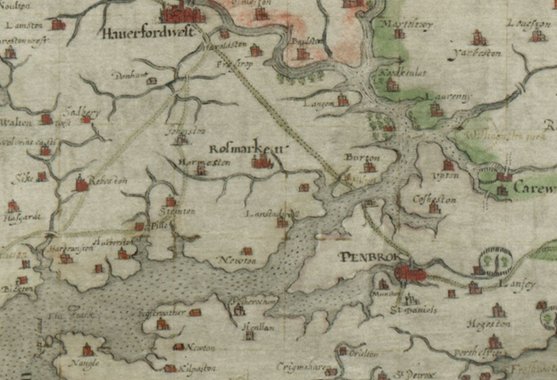
Manuscript map of Pembrokeshire, c1602
This is an important continuity. It suggests that the crossing was already embedded in the borough’s early legal landscape and that by the early fourteenth century it had become identifiable in the record as a named ferry site. The same summary also notes that nearby Kingswood and Bangeston appear in medieval farm accounts, anchoring the passage firmly in a wider medieval landscape of roads, holdings, and ferry rights.[1]
The financial evidence is particularly strong. In the archaeological evaluation of Pembroke Castle, it reproduces part of the 1461 to 1462 account of William Herbert, Treasurer of Pembroke in the first year of Edward IV. Among the receipts appears the entry “Passag(i)um de Burton”, followed by a note that it was “for 6s 8d from money received from John Dynet at his fellows farmers.” That matters because it confirms two things. First, the Burton passage was still a recognised ferry in the mid fifteenth century. Second, it was being farmed out for revenue. This is not hearsay or romantic local memory. It is revenue administration in a lordship account.[2][3]
The practical importance of the crossing also comes through in later references. Pembroke Dock Town Council’s summary notes that the wooden ferryboats could carry substantial loads. In 1500 the ferrymen had to agree to pay for damage if they failed to provide straw to protect the boat’s planking against heavy cargoes of timber and stones. That detail is small but revealing. It shows that these were working ferryboats carrying serious payloads on an established through-route. In 1897 the same crossing could still take two rowers and nineteen Llangwm women with their market goods. That later notice is of course very far removed from the medieval period, but it is useful because it shows the continued carrying capacity and everyday function of the route.[1]
The passage also appears in travel and military history. Pembroke Dock Town Council’s summary records that Lord Cawdor and the Castlemartin Yeomanry crossed here in February 1797 while hurrying to meet the French at Fishguard, and that in August the same year two hundred captives were rowed out to prison ships under guard. A grateful French soldier, according to the same account, removed his hat and bowed towards Lord Cawdor from the boats. Whether one approaches that anecdote as local tradition or as remembered narrative, it still speaks to the crossing’s status as an active strategic route in the late eighteenth century.[1]
There is also ample evidence that the old passage remained a living institution well into the modern period, even if the service could be leisurely. Pembroke Dock Town Council’s history quotes John Wesley in 1772 remarking that “The watermen were not in haste to fetch us over.” He sat on a stone and read while waiting. The same source adds that as late as 1903 ferrymen were still not inclined to hurry their lunch at the Pembroke Ferry House Inn for a single passenger. That slightly comic picture is useful because it reminds us that the passage survived not only in legal documents and accounts but in the ordinary texture of travel.[1]
By the early nineteenth century, however, the old Pembroke Ferry rights were coming under pressure from new economic forces. Pembroke Dock was rising, traffic patterns were changing, and rival ferries were beginning to carry traders and workers to the new dockyard town. We will read in a future article about the Neyland ferry that in 1834 there was a crucial lawsuit in which Mr. Huzzey, lessee of Pembroke to Burton Ferry, tried to assert an exclusive right of ferrying passengers across the Haven and stated that he had exclusive rights to ferry passengers from Neyland to Pembroke Dock. The court decided against him, holding that his exclusive right extended only between Pembroke and Burton and not to the newer Neyland crossings. That judgment is one of the clearest proofs that the medieval passage was still recognised in law even as its monopoly was being overtaken by new routes and new demands. Neyland celebrated the decision with bonfires and fireworks, which is a nice local touch but also a sign of how commercially important the outcome had become.[3]
Seen in the long view, the history of the Passagium is the history of continuity and displacement. For centuries the Burton to Pembroke Ferry crossing was the main route linking Pembroke with Haverfordwest. It appears in charter tradition, in place-name evidence, in lordship accounts, in ferry regulations, in travel narratives, and in nineteenth-century legal proceedings. Only with the transformation of the Haven by dockyard growth, engineered piers, steam ferries, and finally the railway to Neyland did the focus move away from the old passage towards Hobbs Point and the later ferry system. Even then, the legal and historical memory of the medieval crossing remained strong enough to be defended in court and remembered in local historical writing.[1][2][3]
So the medieval Passagium was not some shadowy precursor to the “real” ferry history. It was the original crossing that mattered most. It joined the road from Pembroke to Haverfordwest. It generated revenue for its lords or farmers. It carried timber, stones, soldiers, prisoners, market women, and ordinary travellers. It endured in the records from at least the twelfth-century charter tradition to the fifteenth-century accounts and beyond. When later ferry services developed at Neyland and Hobbs Point, they did not create cross-Haven travel from nothing. They replaced and then overshadowed a much older passage whose roots were genuinely medieval.[1][2][3]
References
[1] Pembroke Dock Town Council, “Early Days,” section “Pembroke Ferry,” stating that Pembroke Ferry was the quickest crossing between medieval Pembroke and Haverfordwest; that “The Passage” of Pembroke’s first charter, probably c. 1180, was by 1324 named “Penebroke Fferre”; noting the 1500 ferrymen’s liability for damage from heavy loads; recording the 1797 crossing by Lord Cawdor and the Castlemartin Yeomanry; quoting John Wesley’s 1772 remark. Available at: https://www.pembrokedocktc.org.uk/history/early-days/
[2] Dyfed Archaeological Trust and Neil Ludlow, Pembroke Castle: Archaeological Evaluation 2018 (Report No. 2018/45, published 2019), p. 162, reproducing the 1461 to 1462 account of William Herbert, Treasurer of Pembroke, with the receipt entry “Passag(i)um de Burton” and payment of 6s 8d from its farmers. Available via Castle Studies Trust and related archival copies.
[3] Neyland Women’s Institute Scrapbook, 1950, “Some Notes on the Ferry,” with associated manuscript notes identifying the medieval “Passagium” from Trinity Wharf, Burton, to Pembroke Ferry; stating that the rights were farmed out annually; referring to the Henry Wogan account in the Slebach Papers.
[4] Owen, George. Penbrochiae Comitatus Demetiae Regionis. Manuscript map of Pembrokeshire, c.1602. National Library of Wales, Aberystwyth.